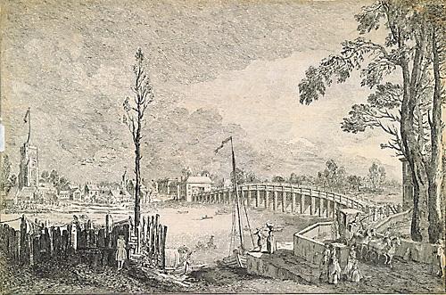
Completed British 18th C, except portraits, British 19th C, except portraits, London: Artists and Subjects, Maritime Subjects 65 comments Where on the Thames is the bridge in this painting?
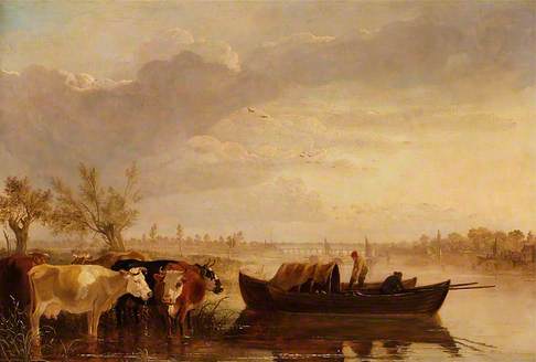
Photo credit: Aberdeen Art Gallery & Museums
The location doesn't look like Chelsea and the bridge doesn't look like Chelsea Bridge. It seems to be somewhere further up the river (though certainly the Thames, from the peter boats in the foreground).
The collection comment:
'Our information on this picture is limited and the title is a received one.
At the time the artist was alive there wasn’t what we would call a 'Chelsea Bridge' (the first Chelsea Bridge wasn’t built until the mid-1850s), though the first Battersea Bridge, built c.1730 was, from memory, sometimes called 'Chelsea Bridge' . The images I’ve seen of Battersea Bridge seem to give it quite a hump in the middle, which this one doesn’t seem to have.
It does remind me a bit of an image I’ve seen of Putney Bridge, if you were looking from the east to the west (and the tower on the right bank is part of Fulham Palace) from the late-18th century. Both it and Battersea Bridge were of a similar design but I understand that Putney Bridge had less of a hump in the middle.
Putney (which would be the left side of the picture) at the time of the painting was still a rural agricultural area. I’m pretty sure that at the time the painter was in London the only two timber bridges on the ‘London’ stretch of the Thames were Putney and Battersea, the few others were stone. Kingston Bridge was still wooden at the time and could be an alternative contender.'
Pieter van der Merwe, Maritime Subjects, Entry reviewed by Art UK
Completed, Outcome
This discussion has been closed. The location was identified as (Old) Battersea Bridge, which was in the past referred to as Old Chelsea Bridge.
Thank you to all for participating in this discussion. To those viewing this discussion for the first time, please see below for all comments that led to this conclusion.
64 comments
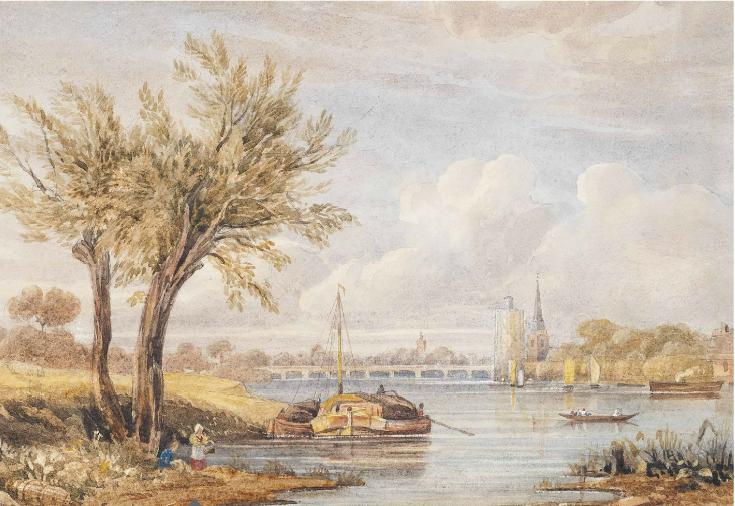
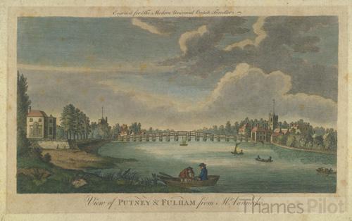
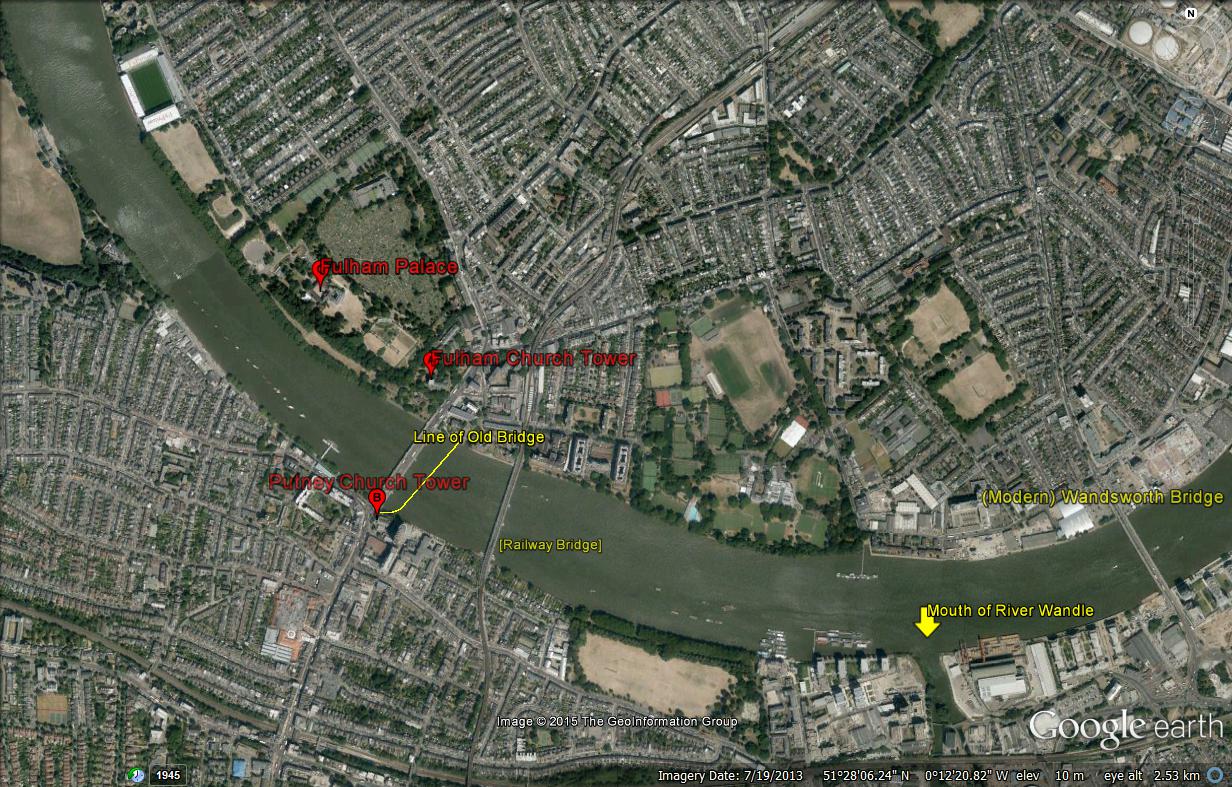
There are three views of the bridge on the Museum of London's site. These , the watercolours by Joseph Farington [ print in the British Museum after this]and John Glover [The Fitzwilliam Museum], the etchings by Chatelain and Whistler and Ned Swain [impressions in the British Museum] all tend to support the hypothesis that this is Putney Bridge, provided that one allow that a mast in the middle of Burnet's oil obscures the undoubted slight rise at the centre of the bridge
There must be many other eighteenth and nineteenth century views of the old Putney Bridge with which to compare this
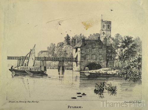
There is an aquatint by W Pickett of 1799 in George III's topographical collection in the British Museum, also on line. Also a 1837 watercolour of the bridge by George Harley
I should add that the church's position fits this identification too. St Mary's Putney is very close to the bridge on the south bank . So this Thames view is looking east towards London
Thanks Martin: can you be specific on which tower on the right is what building, and perhaps provide as close an image link as possible?
I think that this is a distant view of St Mary's Putney. Fulham Palace, if the view is seen from the east, might well be not visible from this point
The tower of Fulham Palace never seems to have risen far above the height of the surrounding complex - the tower of Putney Church was a very much more discernible landmark from a distance, standing proudly quite a height above the chuch.
In 1770 there was a cap to the Fulham Palace Tower - see an anonymous etching in the British Museum
If one was looking west, one should have seen the Putney Church tower much more clearly than Fulham Palace. There is a second tower on the left behind the cows quite some distance from the bridge,which I have not so far been able to identify
I'm still lost I'm afraid. Reading from L to R I can see a square [church?] tower above the cows, just right of the left-of-centre (leaning) willow tree: close on the other (right) side of the bridge is what appears to be a church spire, then at far right, above the waterfront 'sheds', a low tower with what appears to be an onion-dome on top.
Putney is on the south side of the river, and St Mary's church is right beside the modern bridge on its east side, with a prominent square medieval tower . If the view were west to east, the spired church immediately right of the bridge is in the correct place for St Mary's but the spindly spire doesn't fit. The artist's back would also be to Fulham Palace on the north side of the river, which makes the 'onion dome' feature far right something else unidentifiable, as so far is the (?) church tower seen above the cows to left of the bridge. The sun would also be at practically due south (right) and this is not a high-noon scene: its either early or more probably late in the day.
However, allowing some artistic adjustment of the spatial relationships, and supposing the artist is looking west (or ratherslightly north-west) from the south side of the river east of Putney, the spired church to right of the bridge is much more like the 15th-century All Saints, Fulham, and the 'onion' dome is in about the right spot for Fulham Palace beyond. That church is not in fact so close to the river but that may just be artistic licence (or angle of viewpoint when sketched, since this is hardly plein-air work): this might also explain the square tower on the south side above the cows as perhaps St Mary's, Putney, but shifted slightly further away from the bridge than it really is. The further round the curve of the river to the east the sketching viewpoint might have been before losing the view behind the bend (which would be just east of south side of modern Wandsworth Bridge) the more explicable the spatial relationships here suggested would be. Effectively, from such a distance, what is shown within the frame here would be a central detail of a wider view, but editing of that sort is nothing unusual. Its still a better topographical explanation than Chelsea, and the lighting would fit with a late-summer evening with the sun a little north of west, which is where it in fact sets at that season.
Does that make sense or is it bending things too far?
Is the tower to the right of the bridge not the old mill at Battersea? For me this could be the same view:
http://www.christies.com/lotfinder/drawings-watercolors/follower-of-john-varley-old-battersea-bridge-5649572-details.aspx
This is a view of Old Putney Bridge - the churches at either end are squat and partially obscured in foliage, but I'm sure it's this bridge.. Type Old Putney Bridge in Google and hit images and you'll find lots that compare well..
Ah, what I thought was a 'hat' on the tower is possibly a bird!
There is a sketch of the Old Putney Bridge by J M Turner in the Tate Collection.(ref: D22453 Turner Bequest CCXL 68 ) It is represented on line if the person reading this wishes to follow up. The bridges represented are similar/same so I would concur that it is Old Putney Bridge in the background of this painting.
This is for Charles and Tim in particular. Given the PCF image is low resolution and not usefully enlargeable, could you please be explicit (rather than circling circumstantially round the point) about which direction the artist is looking?
What is the church tower immediately right of the bridge (which to me looks like it has a pointed 'spire', but Tim seems to say is an illusion caused by a bird being included there)? If it is St Mary's, Putney (which - today at least - has a square tower with a flat roof) then the view is broadly west to east. If that is the case then remaining topographical queries are the identities of (a) the 'onion-dome' lower tower on the far right edge of the canvas and (b) the square tower - possibly a church further east- visible in the distance above the cows, just right of the larger willow tree (??).
If the view is east to west I have already suggested how that might be explained, but am happy to be shown as wrong. I'm afraid I don't find any help in the Turner sketch mentioned. The proximity of St Mary's Putney to Putney Bridge is not at issue: what is - at least to me from the lack of visual resolution in the oil image as accessible here-is whether that is , beyond question, the church shown immediately to the right of the bridge in it.
I thought it was a spire, then I thought it was an illustion caused by a bird - high res request please!
I have lived in Putney for over 40 years, and have a long-standing interest in old pictures of the locality...but this is a tricky one! The first thing to be said is that we badly need a higher-resolution image - at this size it is impossible to be sure what is intended here. I am still torn between Battersea and Putney, and without a closer look at the tower on the right, and with the extra challenge of artistic licence, I think a resolution is unlikely.
Right, Battersea. Tim’s idea of it being a facing-downstream view of Battersea Bridge & horizontal mill (built 1788, taken down 1825 – the ‘sails’ were inside the louvred structure) is attractive – but the structure is not the right shape or prominent enough, and where is St Mary’s Church, which should be close by? See attached images A & B. But I do still think it possible that the view is Battersea Bridge looking upstream, and that the tower on the right is Chelsea Old Church, close to the end of the bridge (it formerly had a cupola on top, attachment C). See Thomas Girtin’s similar view, much admired by Turner (somewhat mis-titled, as the ‘white house’ is in Battersea Fields) : http://www.tate.org.uk/art/artworks/girtin-the-white-house-at-chelsea-n04728
Our artist, though, would have had to eliminate all the Battersea buildings on the left (including the horizontal mill) for a more rustic feel – and if we accept he might have done, then he could just as easily have eliminated the ugly mill from Tim’s downstream view, and we’re back where we started. Having said that, I don’t think the ‘tower’ is the right shape for the new (1777) St Mary’s Battersea, which has a proper spire – but can’t be sure in this image.
I’ll take on Putney in another post.
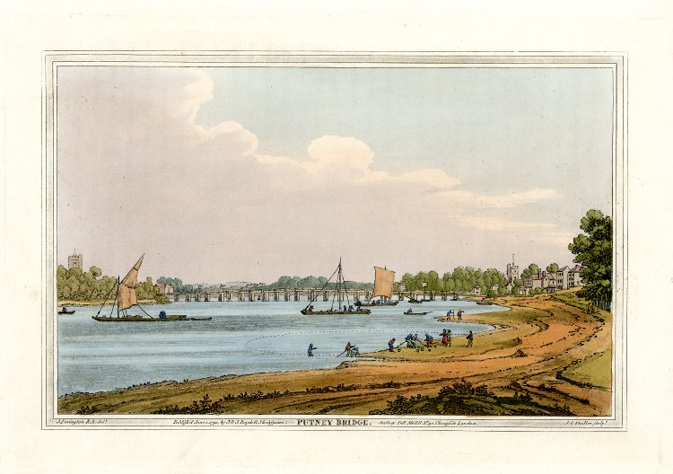
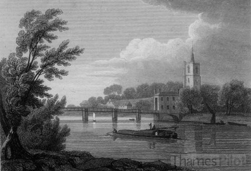
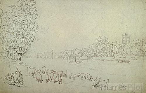
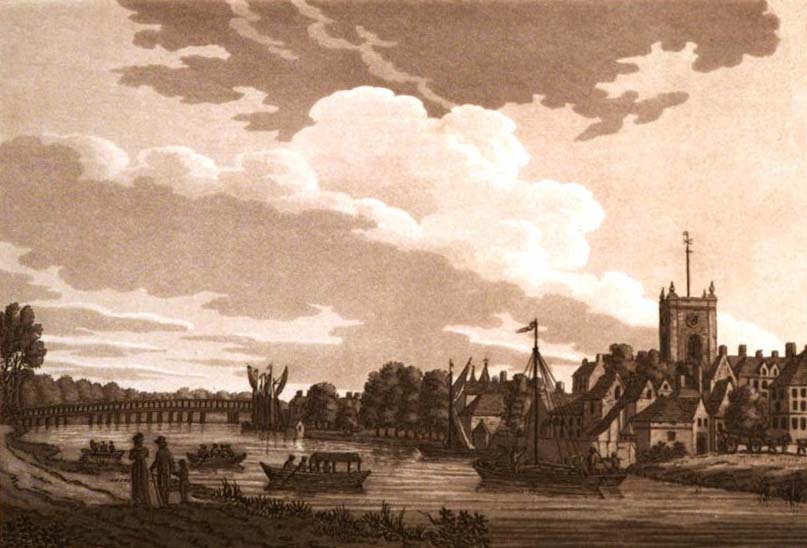
Now Putney. My first thought was that the river is too narrow & the bridge too short for Putney: see attached image D for a diagrammatic representation of the whole bridge looking upstream. My second was that the view lacks the very notable feature of Putney Bridge, the ‘twin’ churches with substantial towers at BOTH ends (St Mary, Putney and All Saints, Fulham). Putney Church was very close to the end of the old bridge, Fulham was set back a bit. See image E for one full-width view (1794 Boydell after Farington) facing downstream – Fulham is left, Putney right – and F for another, both from the right bank.
Going back slightly, there has been some confusion here about the Fulham ‘tower’- unsurprisingly, as the BM have made a dog's dinner of their entry for the 1770 etching Martin mentioned from Chamberlain's 'History of London'. The BM’s print is the upper part of the original page, and shows Fulham Church & Fulham from the bridge (i.e looking roughly north). The lower part shows Lambeth Palace, not Fulham Palace - see https://play.google.com/books/reader?id=cuhWAAAAcAAJ&printsec=frontcover&output=reader&hl=en_GB&pg=GBS.PA620-IA3
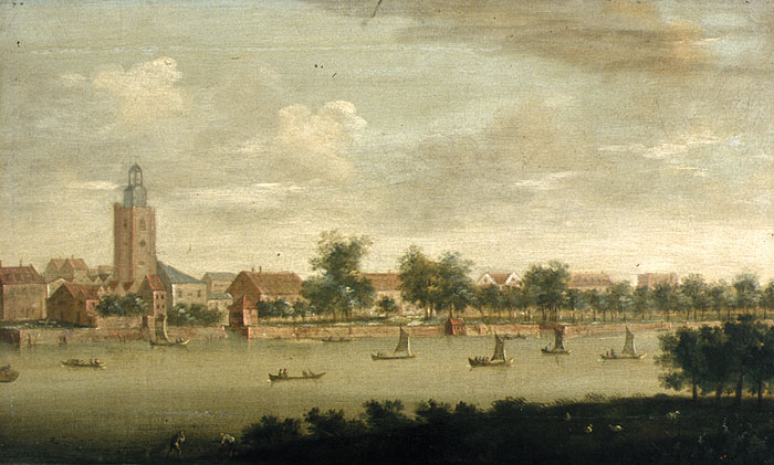
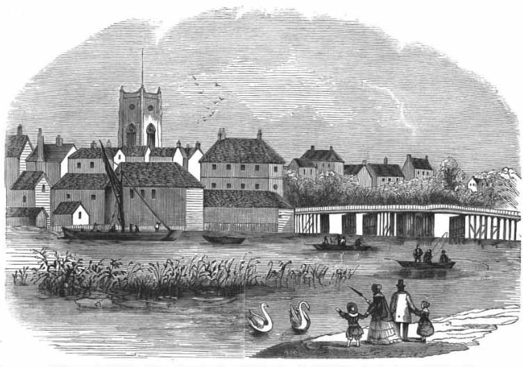
The little spire on top is - or was until the mid C19th - on the tower of Fulham Church. Fulham Palace, though altered several times, was always a relatively plain and low group of buildings, with just a little clock tower over the porch that doesn't even break the roof line: https://londondiaryblog.files.wordpress.com/2013/11/img_0457.jpg . I think it’s extremely unlikely that it ever bore an onion-shaped dome; and looking at the angles on Google Earth, if the tower on the right *is* Fulham Church (All Saints), the ?dome feature is much too far right to be the Palace: it would have been behind, or even to the left of the church tower. The Palace lies about 1/4 mile upstream of Fulham Church, and is 100 yards or so from the river. It was always well-wooded - "The grounds of the palace are remarkable for the thickness with which the trees are planted" ('Old & New London' 1878) - and it's unlikely any of it would be visible in a view like this, whether from upstream or from down. Fulham Church, however, is a different matter. It is about 1/4 mile upstream of where old Putney Bridge (often known then as Fulham Bridge) began, and its tower was perhaps 80 yds from the river (before it was embanked) – I would expect it to be visible in a view like this, as the tower is tall and prominent, and always shown by artists painting/drawing the Fulham side of the bridge. See attached images 1,2,3,4,5. You will see, too, that on the Fulham end of the bridge itself, astride the roadway, there was a substantial and distinctive toll house, also always depicted by artists.
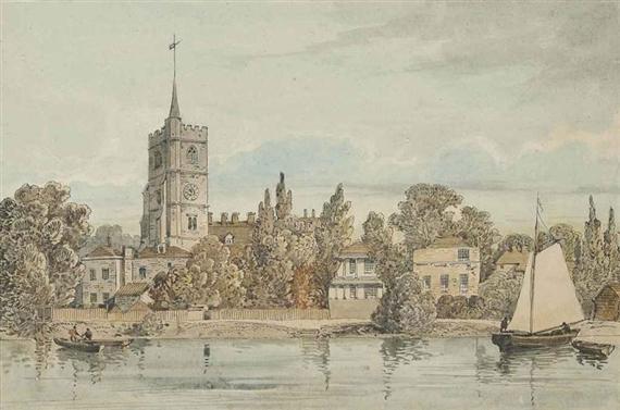
So if the picture under discussion does show only one riverside church (but I’m not absolutely sure of this from the image), we seem at first glance to have a problem. The tower of Putney Church (St Mary) opposite is also prominent and seems always to feature in pictures - it was even closer to the river bank, and of a good height. See attached images 6,7,8. It also bore a squat mini-spire at some stage.
BUT...if the artist were above the bridge and facing downstream (i.e. facing east-ish), and painting from the left bank instead of the right, one can imagine that Fulham Church tower might disappear behind the trees around the Palace – look again at E & F. The toll house, too, might get lost behind the trees. Putney Church would remain visible on the right, and that end of the bridge (which curved sharply right at the end) would become visually mixed up with the buildings of Putney. But we have the light issue if we’re facing that way, and I’m not convinced by the little I can make out of the jumble of shapes at both bridge ends.
If instead we’re below the bridge looking up river (i.e. facing slightly north of west) – G is the only full-width view looking that way I can find – could Putney Church have disappeared behind the trees visible downstream of it in several images? Possibly, yes – or could it be the thing sticking up next to a tree, almost vertically above the LH prow of the rear boat? The (?)church tower above the cows is surely much too far left to be it? I would like the latter to be Wandsworth, but it’s not possible: I can’t see the viewpoint being nearly as far downstream as (modern) Wandsworth Bridge – if it were, the other (RH side) bank would much further across. More like (modern) Wandsworth Park, or possibly the River Wandle delta.
But I’m flailing here – I do think this may all become clearer with a more detailed image.
[Sorry there are so many attachments - the links to the images on the Thames Pilot website (where many were found) are incredibly long. It won't let me do the last two or three, so I'll attach them to a supplementary post.]
The last three attachments
Interesting, if genuine, sketches of Putney Bridge from Putney in the south and Fulham on the north bank.
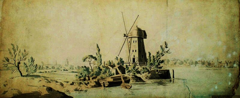
a painting in Chelsea Library simply entitled 'View with Windmill' by unknown artist is another view of Putney Bridge this time showing both the parish church of Putney on the right. It probably dates from early in the nineteenth century
http://www.bbc.co.uk/arts/yourpaintings/paintings/view-with-windmill-179370
Looking back over all this and the images, it would clearly help to have a higher resolution one of the picture to see detail but the question originally raised was a doubt over whether it was Chelsea, as the current title states, and it clearly isn't.
The identifiably salient features are (1) a square church-like tower to some way left of the bridge; (2) a building or buildings with a pair of chimneys and smoke rising faintly from that on the right, on the left abutment of the bridge; (3) a church tower with a small turret very close to right of the bridge; (4) what (at least to me) looks like another lower tower or building with an apparent gold/ coppery onion dome at the far right margin of the picture.
All the various images ingeniously produced above (esp. of the relevant churches) suggest it is what most seem to think: that is, Putney Bridge. As the churches are still there, even a modern map confirms the view is from upstream (west), with All Saints, Fulham, being the square tower to left (noting that I mistook another spired All Saints for that in an earlier note), and St Mary's, Putney close by the bridge abutment to right: both of course were and are on the same north-south (left-right) road over the bridge, the former on the upstream side, the latter on the downstream. Images that Osmund and Martin have produced clearly show the toll house and other buildings close on the Fulham end of the old bridge: these are not easily seen on the painting, but indicated by chimneys and rising smoke. The artist's direction of view is broadly south-east, and the light in the picture south-west to west-south-west (i.e. early evening, as the tone also suggests). The only still unexplained feature is the 'onion-dome' tower at far right, unless I'm misreading that.
One can also apply negative proof: that is, if not Chelsea or Putney bridges, then it has to be another one - and it can only be further upstream- with similar buildings relationships and though I've not made a list and checked all its not Richmond, Walton, Windsor, Maidenhead, Caversham.....
Is a hi-res image available? That should nail it. If not than 'Old Putney Bridge, from the west' is at least a better provisional description than the present title, which is simply wrong.
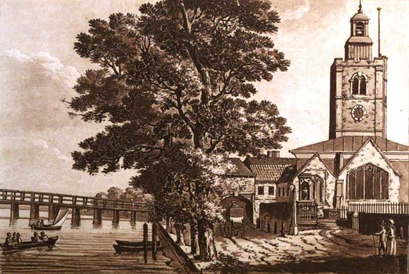
Martin, the Chelsea Library painting is not of Putney Bridge: it is a copy (probably via the print) of Thomas Girtin’s view up Chelsea Reach to Battersea Bridge that I mentioned in an earlier post : http://www.tate.org.uk/art/artworks/girtin-the-white-house-at-chelsea-n04728 . On the left are Battersea Fields and the Red House windmill, with the Horizontal Mill and St Mary's, Battersea spire beyond; on the right is Chelsea Old Church.
Thank you, Osmund, very much for correcting me. An obsession with Putney Bridge misled me. However , the description of the Chelsea Library picture on BBC Your Paintings does need emendation
Alright: then bringing Chelsea back into possible play we have the options that its still not Chelsea Bridge, but old Battesea Bridge looking west (or upstream, as in Girtin) with Chelsea Old Church on the right (but avoiding the Red Mill out of frame left and with no sign of the White House (as shown by Girtin): or - as above - its a downstream view from above Putney Bridge.
Could Aberdeen please produce a higher-resolution image, or at least of the topographical details either side of the bridge -including the apparent 'onion-dome' feature at far right?
I have asked Aberdeen Art Gallery & Museums if they would concede to post a higher resolution image of this painting, and will report back any response.
I am afraid the Aberdeen Art Gallery & Museums cannot grant the request for a high resolution image to be posted on Art Detective.
Thanks Jade: can they provide large detail low res of the details (I-pad?), or take a view themselves? E.g. the left end of the bridge is either going to be the distinctive Fulham toll house on that end if it's Putney or (if it's Battersea Bridge) the White House as shown by Girtin is going to be just this side. All the comparator images are included here above.
Aberdeen Art Gallery is currently closed for a major, HLF-funded redevelopment and our collections are in commercial storage so it is not possible for us to take an image of the detail. We have tried to enlarge a detail from the Tiff but it was not successful. I can ask our photographer if she has time to take a look and get back to you. Interesting discussion!
ThanksAberdeen: can you just keep us up to date?
PCF- is there anything we can do to show this is on hold as for resolution as whether in fact old Battersea Bridge from the Chelsea (east) side, or Putney Bridge from the west?
The shape of the bridge surely militates strongly against an identification with old Batttersea Bridge at this date
Thanks Martin. If you look at the Collection comment at the top you'll see (they say) that there wasn't a 'Chelsea Bridge' (ie in the present position east of Chelsea Hospital) until later, but that in the present position of Battesea Bridge (which is the sense I am using Battersea as regards the one perhaps in this pic) was then also/alternatively called Chelsea Bridge. Plenty of evidence has also been presented for the Putney option. I'm not taking sides except to say I don't think this debate is going anywhere except round in circles until we get some more detailed images to confirm the topographical details more precisely than the present one allows.
Pieter, I have been up half the night preparing some old maps and images from Google Earth (with annotations and lines of sight), and I believe they show convincingly that Old Putney (aka Fulham) is impossible, and Old Battersea (aka Chelsea) is not only possible but very likely. I need to go to bed now, but will post later!
To avoid confusion we need not to refer to Chelsea as 'Old Battersea Bridge'. That was built 1771-2 by John Phillips under the direction of Henry Holland. This is the bridge with a very distinctive rise much represented by Whistler in prints, drawings and paintings, as well as by other artists . This was closed to traffic in 1883 and demolished in 1890, the year in which the present bridge. Most people reading 'Old Battersea Bridge' will assume that the 1771-2 bridge is under discussion
I'm really confused now. Are we saying there was another bridge, I mean other then 'Old Battersea Bridge' in the early 19the century on this stretch if the Thames? (Assuming, for the purposes of my question, that we aren't talking about putney bridge).
It's true the bridge has a hump in some pictures, eg by Whistler, but equally there are photographs of it looking pretty flat, such as the one here (you have to scroll down to the 9th photo on the page):
https://rbkclocalstudies.wordpress.com/2013/08/01/100th-post-bignell-meets-hedderly/
Thanks Osmund, Martin and Richard.
Please remember that the original query was regarding the titular description of the painting, which currently says 'Old Chelsea Bridge' (and thus by implication states the location shown).
It is clear from the discussion that at the time it was painted there was no 'Chelsea Bridge' (a later construction on the line of Royal Hospital Road much further east), only the original 18th-century Battersea Bridge, at the same position as its current 1890s replacement: so whatever the actual landscape shown, the present title - however originally arrived at- is at best misleading in terms of the relative historical positions of bridges at Battesea/ Chelsea, or plain wrong supposing it were anywhere else further up river.
That's my point: when this was painted, there was no separate Chelsea Bridge. Therefore our main candidates are Old Battersea Bridge and the old Putney bridge. And when Martin H says that "Most people reading 'Old Battersea Bridge' will assume that the 1771-2 bridge is under discussion" then they would be perfectly right to make that assumption. The fact that the bridge at Battersea was sometimes called Old Chelsea Bridge needn't concern us as we are dealing with a topographical question &, whatever its name, we all know what bridge is being referred to.
That's fair enough if you know it, but I didn't realize the comparative chronology of bridges when I raised the matter of the title/ location or I might simply have dismissed the matter and passed on: even those who know a lot don't know everything, and this is also public exchange which may have non-participating spectators who know less and are even more confused or alienated by now!
Remember that the Heatherley photographs are from an elevated position compared with the many views from river level or from the riverside
I quite agree, and it also explains why whistler et al made the hump look bigger, when they were looking from below. My only point was to clarify that, if our painting shows a bridge on the Chelsea/Battersea stretch, then it must be the bridge we usually call Old Battersea Bridge. Because there wasn't another bridge at that point in time.
Pieter did address the matter in his original discussion introduction, though I quite understand that those unfamiliar with the area's history may still have found it confusing - it was actually built in 1771 rather than 1730 (the latter more or less the date of Old Putney Bridge, which opened at the end of 1729).
While I agree with Martin and Richard that a low viewpoint of Old Battersea Bridge would tend to accentuate the hump (and a high one lessen it), a more significant 'humping' effect comes from having the viewpoint close to the bridge's end - getting further and further from it and looking at it more from the side, the bridge progressively seems flatter. Compare Walter Greaves's high-but-close-to-end viewpoint here: http://www.gac.culture.gov.uk/work.aspx?obj=17953 with other views of his moving gradually away (and also with differing degrees of artistic tinkering): http://www.victorianweb.org/painting/greaves/paintings/5.html
http://www.waterman.co.uk/artists/periods/1/33/
Those are all from the upstream side looking down; but look at what the same artist now does with a more distant view from downstream looking up - the hump has almost disappeared:
http://www.christies.com/lotfinder/ZoomImage.aspx?image=http://www.christies.com/lotfinderimages/d56163/d5616342&IntObjectID=5616342&lid=1
Other artists play around with it, too - you can find countless examples on the net. Here's an 1804 Daniel Turner of the Battersea end of the bridge with a completely flat roadway: http://www.christies.com/lotfinder/ZoomImage.aspx?image=http://www.christies.com/lotfinderimages/d55879/d5587988&IntObjectID=5587988&lid=1
Henry Pether c1850 also minimizes it: http://www.bbc.co.uk/arts/yourpaintings/paintings/chelsea-by-moonlight-179342
On the other hand this very useful 1834 upstream view by Thomas Creswick allows it its proper hump, even from a distance: http://www.bbc.co.uk/arts/yourpaintings/paintings/view-of-the-thames-at-battersea-33529
Thomas Girtin’s view from the same sort of area, however – the one we looked at before – not only flattens it again, but fattens it considerably and lightens the colour, purely for artistic effect: http://www.tate.org.uk/art/artworks/girtin-the-white-house-at-chelsea-n04728
Girtin also plays with several other aspects of reality. The Horizontal Mill on the left, for example, is accentuated/brought forward - it was actually well beyond the bridge, and from that angle little higher than the church spire close by it. And this is the point: from almost any artist but a topographical draughtsman we must expect some adjustment of angle and precise bridge shape – though a close look at the bridge in the painting under consideration does in fact show a slight rise to the centre, though that would not rule out Putney which also had one, albeit less prominent than Battersea's.
Thanks for these further imagesand interpretation Osmund: is this also your agreement - subject to whatever better details of the picture itself confirm- that it is 'Old Battersea Bridge' viewed from downstream? If it is Chelsea Church on the right what might the apparent 'dome' at far right be?
Sorry not to respond quicker, Pieter. Yes, it's now my view that this is Old Battersea (alias Old Chelsea) Bridge viewed from downstream. I think that the reason the windmill and the Red House are absent is quite simply that it was painted from a point somewhat to the west (i.e. upstream) of the latter. Thomas Girtin’s ‘White House’ is not to be seen because the White House is, I believe, in reality just the end elevation of the Red - the name even being, perhaps, a deliberate joke (the Red House was a notoriously wild and wicked spot)...but that’s pretty debatable, and for discussion another day!
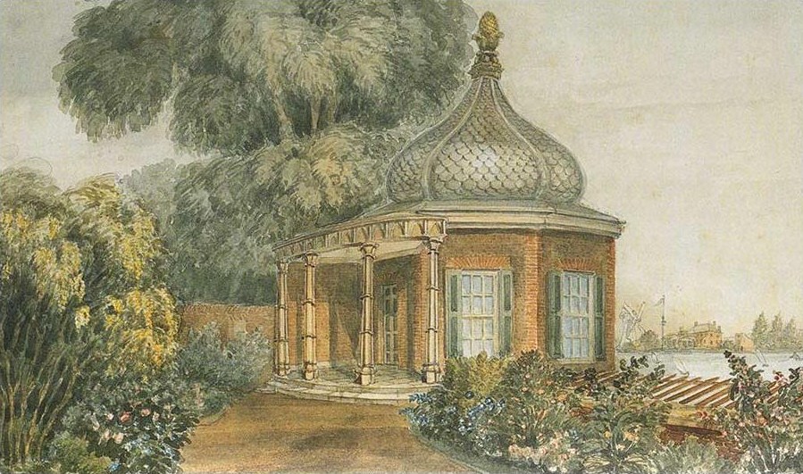
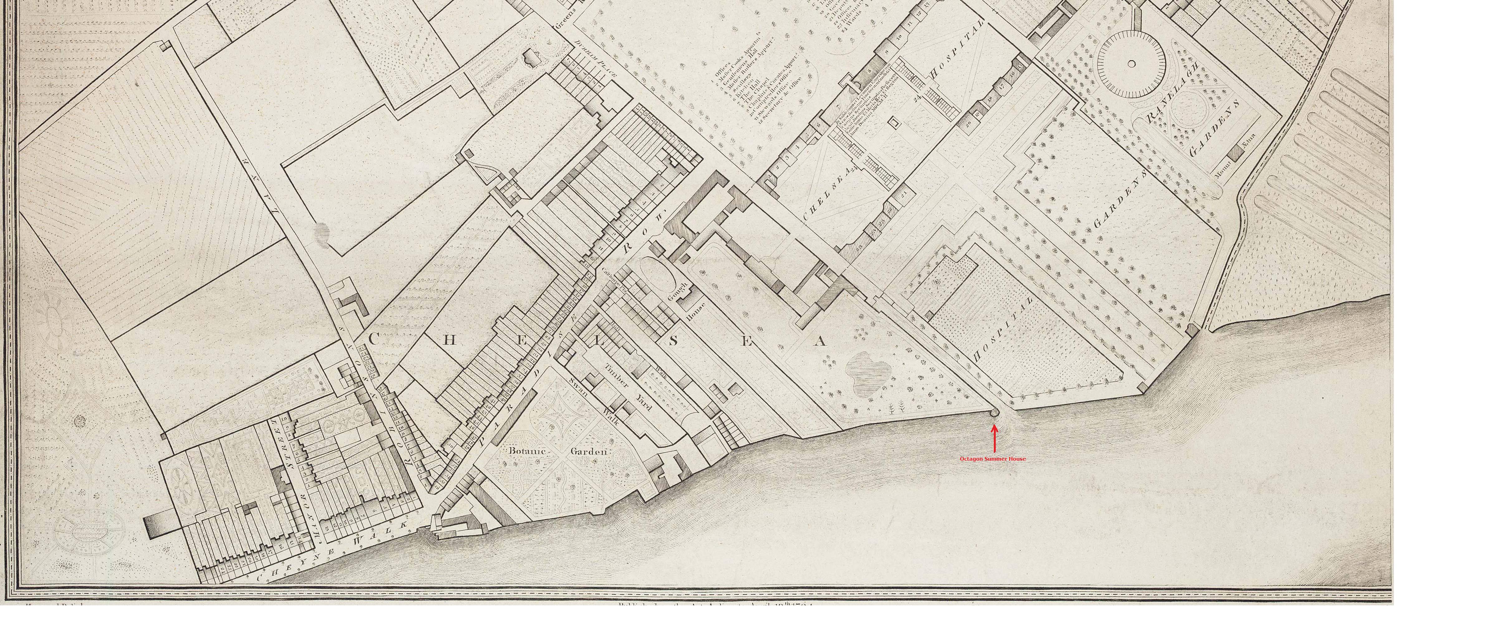
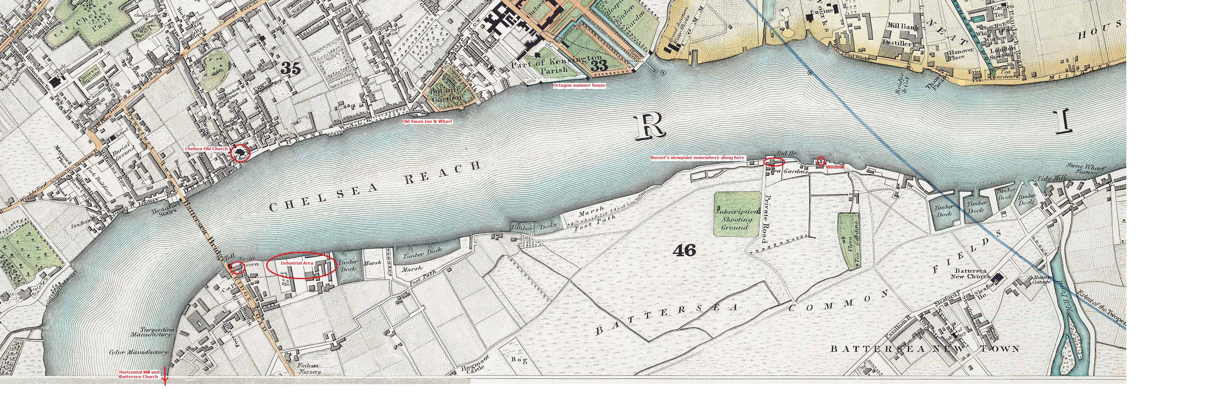
The dome - I was in denial about it being that for quite a while - caused me some head-scratching, but I think I’ve now cracked it: it is not a tall dome on a distant building, it is the riverside octagonal summer-house built by Vanbrugh in 1725 for Sir Robert Walpole’s house adjoining the west side of the Royal Hospital. When Walpole (later Yarborough) House reverted to the Crown in 1809/10, the main building was incorporated by Soane into the new Hospital Infirmary, but the summer-house survived in the garden of a new villa, Gordon House (which still stands), built on the south (river) end of the older house’s garden. See http://www.british-history.ac.uk/survey-london/vol2/pt1/pp3-7
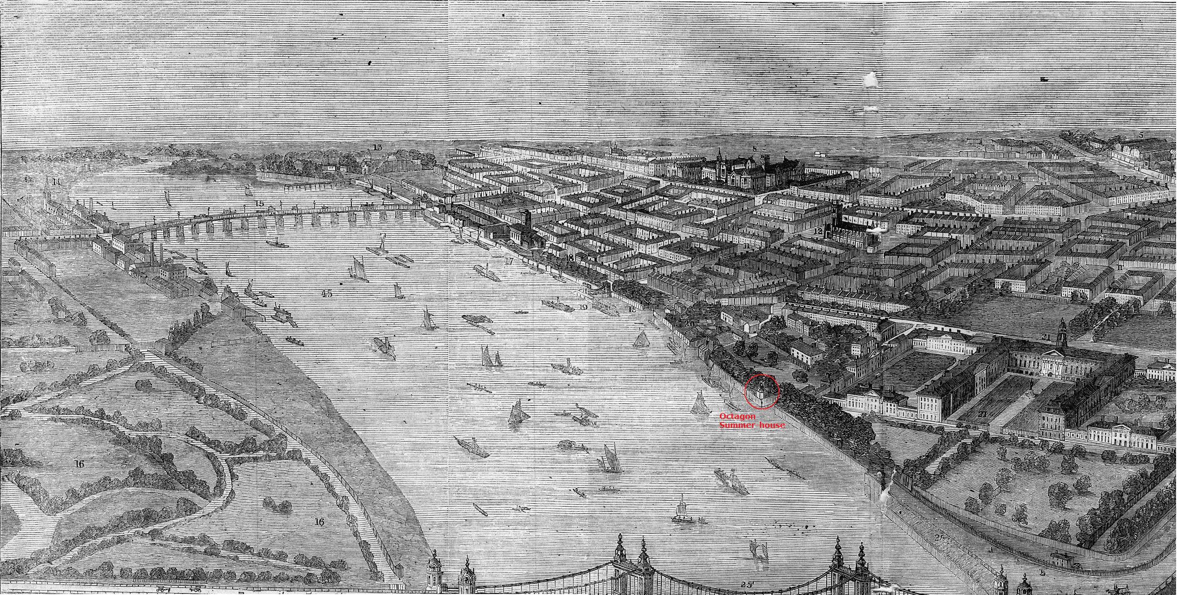
The Octagon with its big onion dome was positioned right on the river wall, and would have been highly visible from across the river in Battersea Fields – in the attached image (a), you can see the Red House and windmill in the background. It survived until 1876, when it was swept away by the new Chelsea-Millbank embankment, though later depictions suggest it had already lost the onion by the late 1820s. Its exact position can be seen on several site plans in the Soane Museum, as well as appearing on a number of C18th/19th maps and vistas – see attachments (b), (c), (d). It also appears in Leigh’s 1829 ‘Panorama of the Thames’ – this fascinating work is now viewable online, and is most useful, in its Chelsea & Battersea sections, in establishing our topography (and also for eliminating Putney Bridge in the Fulham & Putney parts): http://www.panoramaofthethames.com/1829/guide/15-chelsea
Be wary of taking Leigh too literally: he freely alters buildings’ positions and angles to make them clearer, and some of the labels are incorrect. Be similarly cautious with the 1859 Bird’s Eye View (d), which misrepresents much including the river’s bends – for an accurate view of those we must look at maps and Google View, which I will present in another post. For the moment I will just add that Burnet’s true view could not, in reality, have included the Octagon, even at the very right-hand edge – he must have found it so striking that he included it willy-nilly, necessitating an effective shift in its position of nearly ¼ mile upstream (though the angle of view mean that is not as dramatic as it sounds). He must also have raised it a fair bit.
Thanks for that well-evidenced explanation which I find a very convincing one, subject to whatever a higher resolution image of the canvas may add in due course. It removes my initial query as to actual location (i.e. I agree with you -its a somewhat doctored upstream view from the south side of the river with the Chelsea shore on the right) but the title/ basic description needs amendment in some way to identify the bridge as 'Old Battersea Bridge': the cognoscenti may know it was also variably called 'Chelsea Bridge' but I didn't, I doubt its 'general knowledge' , and it isn't helpful to perpetuate confusion.
What's the collection view please?
Hi all - our photographer has kindly cropped a detail for you to study. Hope this helps!
Alison
Lead Curator (Art)
Thank you but oh dear! a case of Rorsach dots and the eye inventing what isn't there as regards the 'onion dome', which turns out to be a tree. I'm still very grateful to Osmund for telling me a great deal I didn't know and was well worth hearing about re: the Chelsea summer house.
Does this change any opinion as to the church being Chelsea with old Battesea bridge to the left? (Would a detail of the buildings on the other side of the bridge also be possible?)
This detail is very helpful as one can now see clearly a slight rise towards the centre of the river in the bridge from the Chelsea end, as well as the trees and open ground in front of the older buildings on Cheyne Walk such as Lindsey Houses. The buildings themselves are too far back behind this open ground to be espied. This changes my view - it is certainly Old Battersea [Chelsea] bridge
Thank you so much for that, Alison...and yes, a cautionary tale for us, Pieter: I'd also become quite convinced it was a dome, and of course thought I'd found it! In one sense it helps, as it means that Burnet doesn't need to have cheated his view nearly as much as we thought (if at all).
I still think it's Chelsea Old Church and (Old) Battersea Bridge. The new image from Aberdeen shows a substantial structure on top of the church tower: neither Putney nor Fulham ever had anything that big, just a little spire (very small on Putney) - see the images I posted a month or so ago. Chelsea, however, did. Attached (1) is a good, fairly contemporary (1802) picture of Chelsea church. The detail of the 'lantern' is different on our picture – but it’s really just an impressionistic background detail. The important thing is that its basic shape is comparable (as it is in Thomas Girtin's view).
The other interesting detail now clear is the tree-lined promenade or road running along the river bank, which is perfect for Cheyne Walk, Chelsea - see these views, which though later (Church tower has lost top structure) are very helpful in showing from our angle the road/walk, and the relationship of church to bridge’s end: https://rbkclocalstudies.files.wordpress.com/2014/09/chelsea-waterfront-152a.jpg https://rbkclocalstudies.files.wordpress.com/2012/11/cheyne-walk-by-moonlight-pether-lw_kcls_t2.jpg
It seems likely, too, that the jumble of building, wharf and boats on the extreme right is the edge of the Old Swan Inn & Brewery (Chelsea). There are several views of it here (nos 5,6,7 down): https://rbkclocalstudies.wordpress.com/2012/11/29/the-chelsea-painter-on-the-waterfront/
Funnily enough, our old (but now unwanted) friend the Octagon Summer House is visible in the right background of the first one, between the big tree and the newly-built (1850s) bridge. Years earlier Rowlandson also drew it, with a sketchy Chelsea Old Church visible through the trees: http://www.britishmuseum.org/research/collection_online/collection_object_details/collection_image_gallery.aspx?assetId=10020001&objectId=742108&partId=1
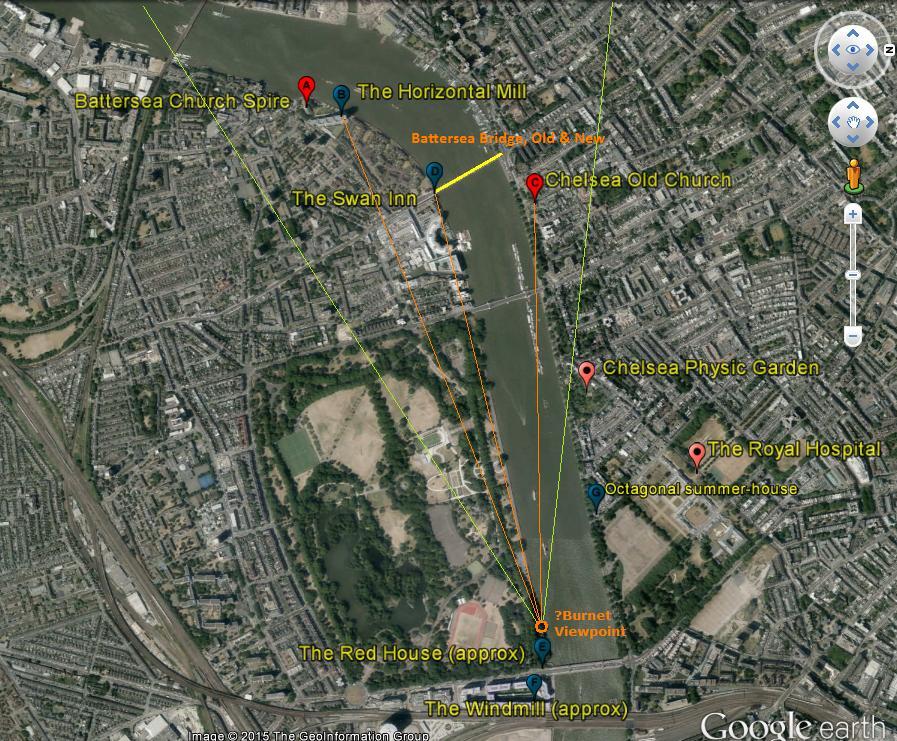
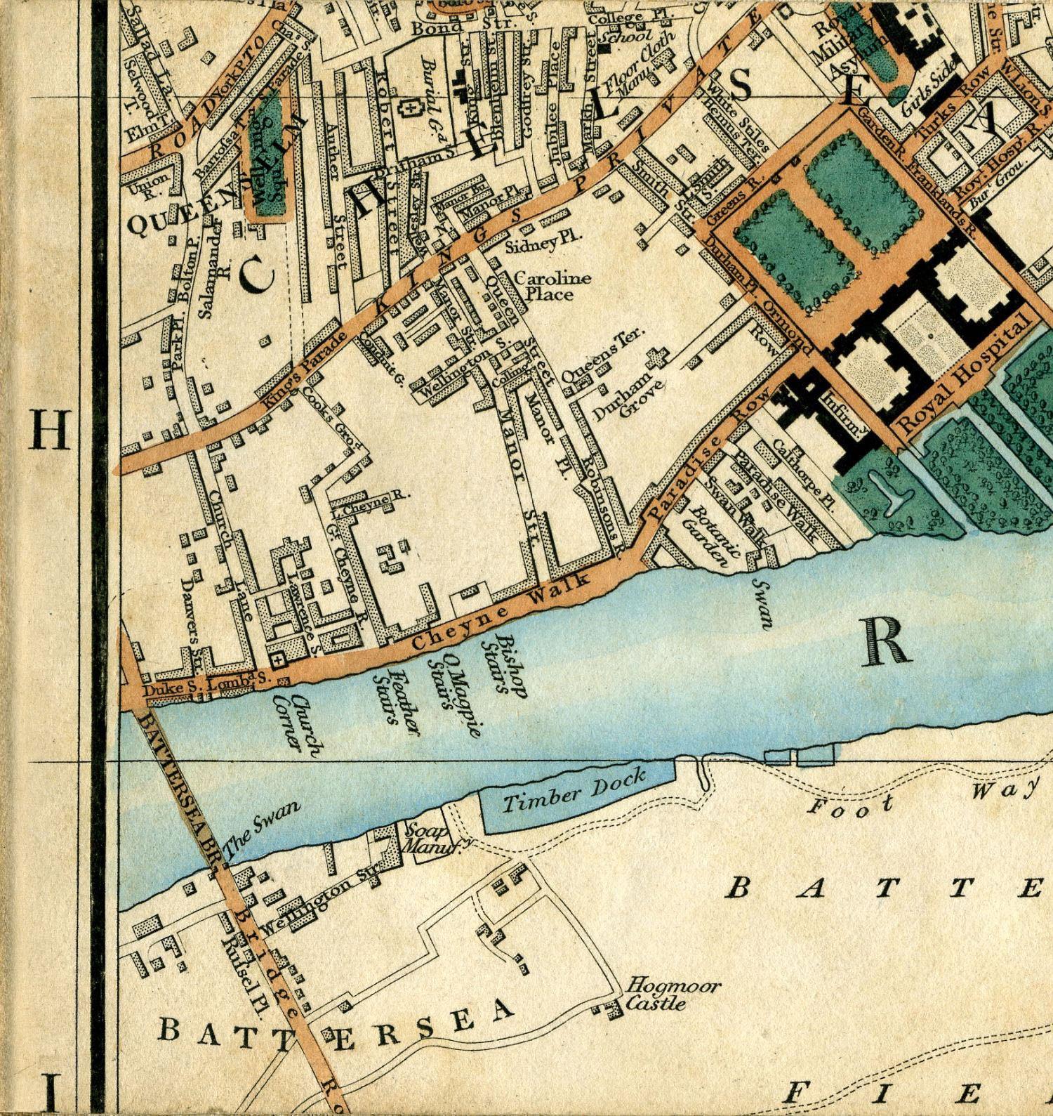
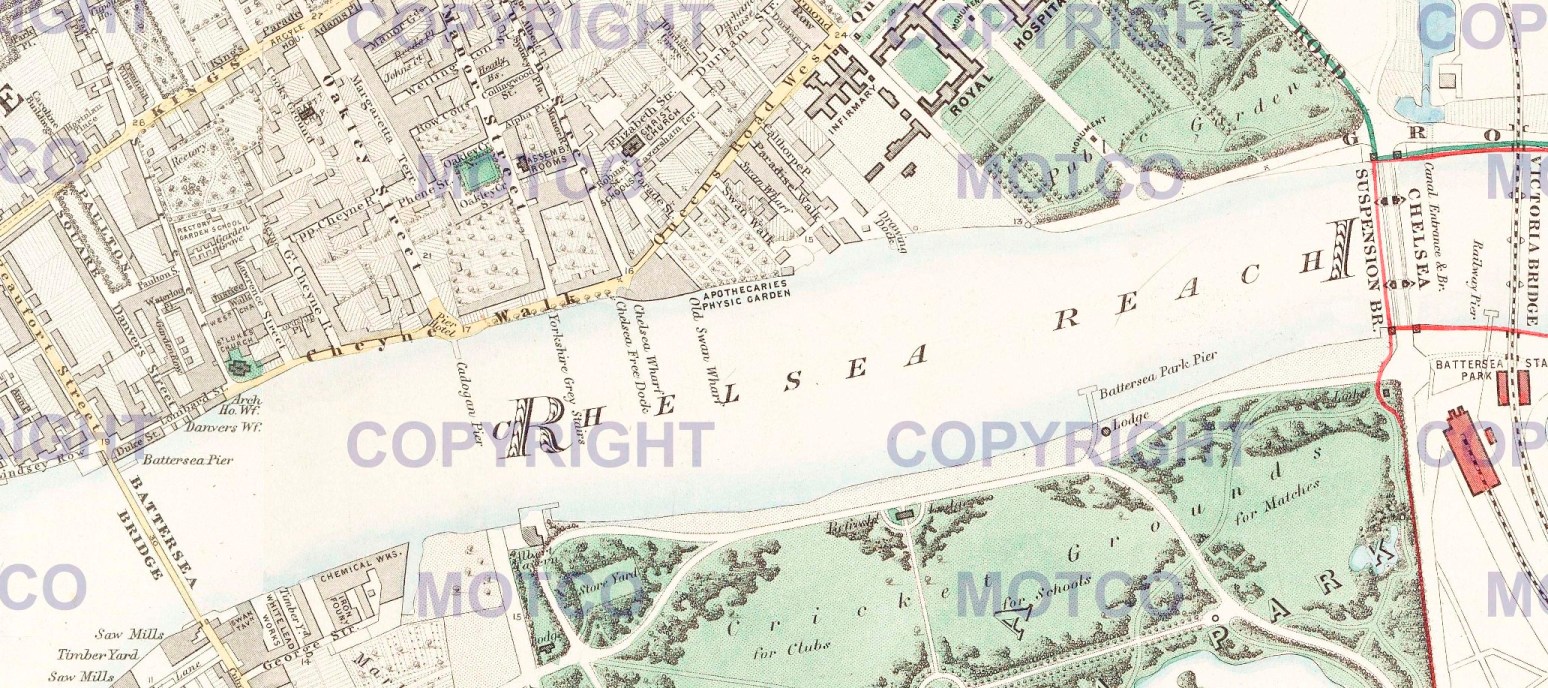
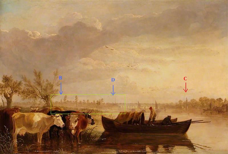
To get an overall picture of how the land lies, attached (2) is a (high-res zoomable) composite of several sheets of Greenwood’s wonderful 1830 map showing Chelsea Reach. And also (3) an annotated Google Earth image, rotated so we’re facing west, as Burnet was. The thick yellow line is Old (and New) Battersea Bridge, the thin green lines my suggestion for the approx limits of the artist’s view, the orange ones his lines of sight to three landmarks, also shown in (4) a marked-up version of our painting. [C] is the church, [D] is the Swan Inn at Battersea, perhaps with some smoky industrial buildings in front (there was a riverside soap factory there); and, less certainly, [B] is the Horizontal Mill – it may be [A] Battersea Church instead, or indeed another tree. (5) is a sketch showing how small the Horizontal Mill & Battersea Church really appeared from a point not much further than my proposed viewpoint (they were nearly a mile and a quarter away). To hit this finally on the head we ideally need a close-up of the area from B to D – I’ve boxed it in the image.
Probably no longer necessary, but in case of any lingering doubts I’m also attaching (6) another annotated (but not rotated) Google Earth image of Putney Bridge and vicinity. I won’t talk it through unless asked – you can draw your own conclusions from the church positions and the river’s shape.
That's an impressive exegesis Osmund, using more IT skills than I can muster, and with lots of useful local knowledge! If Aberdeen could provide the extra image detail, I'm sure they'll get their money's worth by return of post as regards what's going on to left of the bridge, but the end result is really that it would be more accurate -unless 'Old Chelsea Bridge' is an original title to call this canvas 'Old Battesea Bridge from the east' or something similar. So pending another photo from Ablison just to conclude on the topographical details on the Battersea side, I'd like to suggest that change with a view to winding this one up. John Burnet I do know: James not - I must look him up...
You're very kind, Pieter (and I for my part didn't know the word 'exegesis').
Bear in mind, though, you found my lengthy explanation of the dome-that-isn't equally persuasive! To be honest, I will rest easier if we can see the other detail - I am painfully aware that I can be prone to 'confirmation bias'.
PS We never talked about Old Kingston Bridge. Pictures are rare, but the few I can find seem to rule it out both topographically and in appearance - and the church tower (175 yards from, and on ground c20 ft higher than the river) never had a superstructure. A few images attached.
Can we now conclude this by suggesting the title is changed to 'Old Battersea Bridge from the east' or something similar? If the existing one hadn't said Chelsea so misleadingly (albeit an archaic alternative known to the cognoscenti -which did not include me on this occasion) I wouldn't have started this long albeit most interesting discussion to get us back - at least geographically- to where we started.
This has been a fascinating discussion which seems to have concluded that the correct bridge is Old Battersea Bridge.
The query also related to the direction of the view.
Is it actually the case that the view looks upstream from an eastern position as suggested above and, if so, where is the artist actually located or does it follow other examples, like the Varley image and mimic the view downstream from Chelsea Creek ?
I wasn't entirely clear why it is definitely the former.
Pat, if you look at the attachments numbered 2 & 3 in my last post but one (two weeks ago) you will see that I've marked up the detailed 1830 map and the (90 degree-rotated) Google Earth view with my suggestion for the artist's position - which is to say, (at the time) a hundred yards or two west (upstream) of the Red House tavern, Battersea, and looking west along the marshy margins of Battersea Fields. Subsequent online discoveries suggest that the Red House, which I marked as underneath the southern approach to present-day Chelsea Bridge, was in fact slightly downstream (east) of it: its remains have been found in an archaeological dig there. The artist's position would today be in the north-east corner of Battersea Park - more or less in line with the centre axis of the Royal Hospital and grounds, across the river in Chelsea.
Although I would ideally still like to see a higher-res detail of the left-hand side of the bridge, the reasons why I believe the view cannot be from the upstream side are:
(a) Notwithstanding its sketchy nature, the church tower on the right has the wrong shaped top for the 1777 Battersea Church, which has/had a proper spire. It is much more like Chelsea Old Church at the time.
(b) The church (and indeed the bridge itself) is too distant for a view from the vicinity of Chelsea Creek/Canal – and the viewpoint cannot be much further upstream, the inside of the river’s sharp bend would change the whole outlook, and obstruct a big section of the bridge.
(c) Chelsea Old Church would still be visible, but beyond the bridge (as it is in the Christie’s “Varley” watercolour): there is no sign of it. Actually the “Varley” must have been taken from well upstream of the creek; but the view has many cheats, some angles are impossible – Chelsea Church should be much further left.
(d) There is no sign at all of the Horizontal Mill, until 1825 a tall, bulky and very prominent building indeed, about 130 yards downstream from the tower of Battersea Church.
(e) The tree-lined riverside road/promenade on the right is much more likely to be Cheyne Walk – there was nothing similar in Battersea running upstream from the Church, as far I know.
There are several other pointers, but the above are the most simply explained.
I think we've all learnt a lot about the west London Thames from this dialogue, and it could clearly feed into cataloguing quite a lot of other stuff related: however -unless they have a higher res image of the left hand side of the bridge just to wind up - we should perhaps just ask Aberdeen to amend the title of the painting and adjourn further strictly topographical debate to some other forum - a suitable riverside pub with a relevant view perhaps?
I completely agree, Pieter: I seem to have spent most of my waking life on this one in the last few months, and that was intended as my final word (and only then in answer to Pat)! I know plenty of suitable riverside pubs from Wandsworth upstream, but I'll have to investigate further for Battersea and Chelsea...
PCF: please ask Aberdeen to amend title to something like 'Old Battersea Bridge from the east' to avoid the confusion which prompted the query in the first place.
Can we try further collection-nudging for a conclusion to this one please?
The collection has been contacted specifically about this recommendation.
The collection note:
‘Unfortunately the painting is currently in commercial store as the Art Gallery is closed for redevelopment so I am unable to check the label on the back. The painting was purchased at auction in 1954 and is referenced in Irwin David and Francina, "Scottish painters: At Home and Abroad 1700-1900" Faber and Faber London 1974. Francina Irwin was formerly Keeper of Fine Art at Aberdeen Art Gallery and she refers to the painting as Old Chelsea Bridge. Burnet lived and worked in London.
We do not intend to change the title of the painting but I shall make a note on the record. There were a number of opinions as to which bridge this actually is, so perhaps someone involved in the discussion could summarise the conclusions?’
This is what is almost always called Old Battersea Bridge (1771-1885), positioned in the same place as modern Battersea Bridge (built 1887-90). The view is looking upstream (i.e. west) towards the bridge from a point a bit under a mile downstream of it and across the river in Battersea Fields - the artist's position would currently be found in the NE corner of Battersea Park. Annotated Google Earth view re-attached [1].
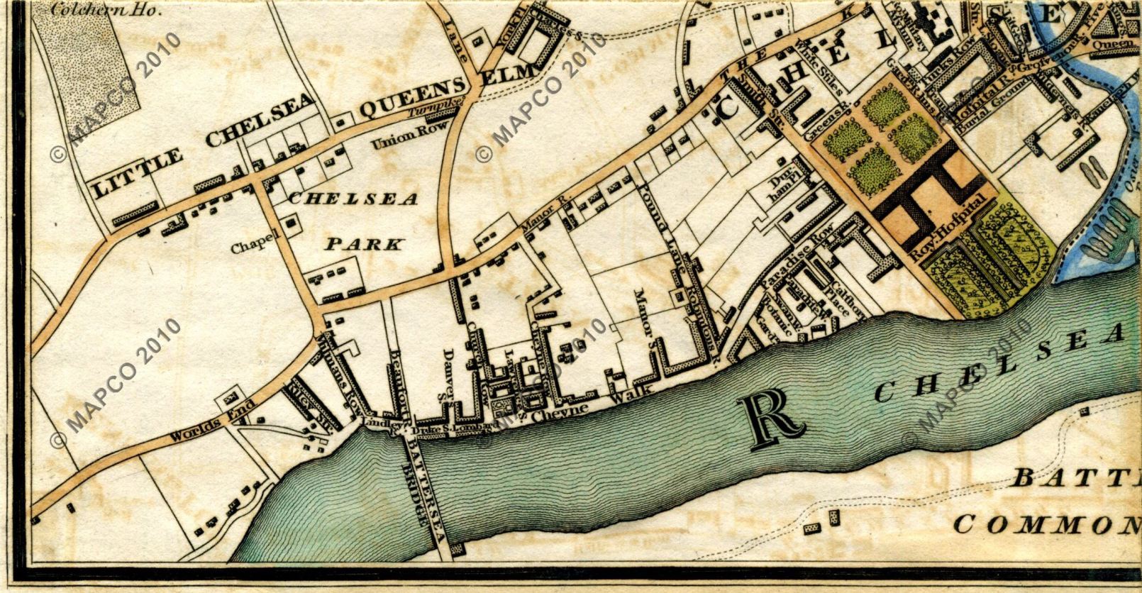
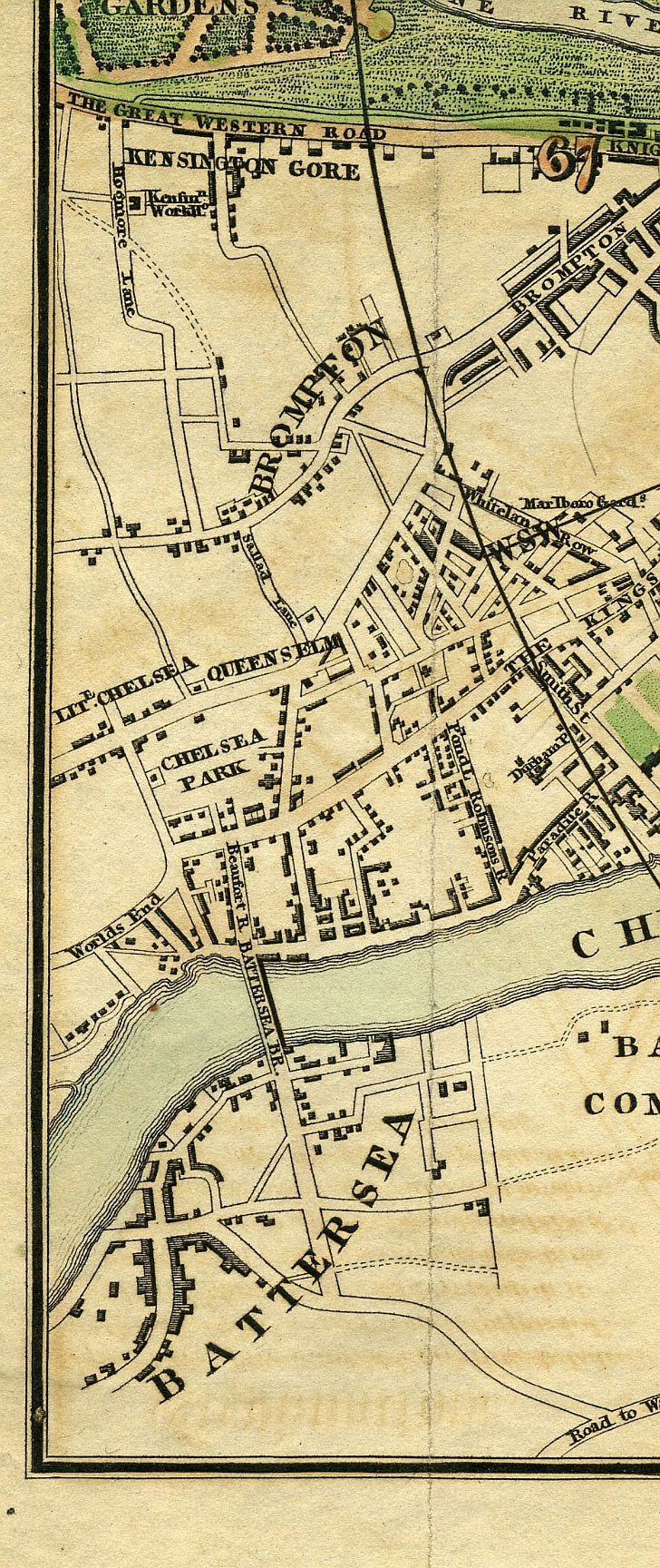
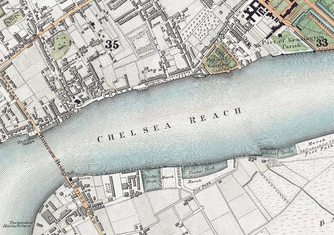
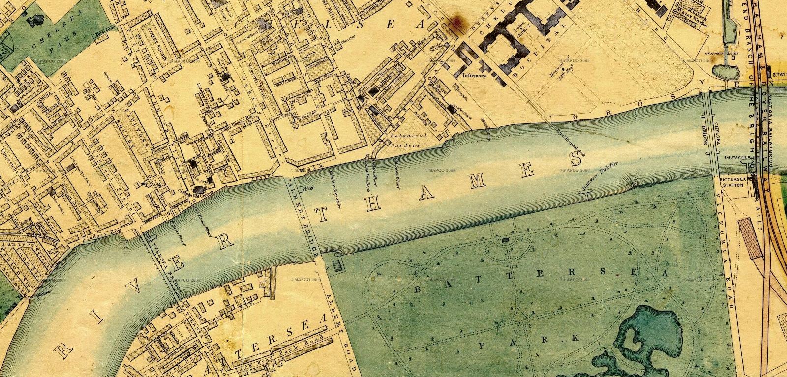
I am sorry the collection does not wish to change the title: much confusion may be caused in the future thereby. Historically it was indeed sometimes known as Chelsea Bridge - but far more commonly as Battersea even in the late 18th/early 19th Century (see attached contemporary maps [2-6], good and bad, 1795-1837). Moreover in 1858 another bridge (initially called Victoria Bridge) was opened a mile downstream, and contemporary maps show this new bridge had become known as Chelsea (Suspension) Bridge not long afterwards (see attached maps [7-8] 1862-1868). Since then the bridge under discussion has always been referred to as (Old) Battersea Bridge, most notably in the many famous views of it by Whistler and Greaves of the 1870s/80s. This has become even more important in the years since the 1858 downstream bridge was itself replaced in the 1930s by the current Chelsea Bridge, meaning that 'Old Chelsea Bridge' is now understood to refer to the predecessor of this one, NOT to the bridge under discussion a mile upstream .
Complicated, I know, but that is as clear as I can make it.
(My thanks to Mapco.net and Motco.com for all these wonderful online historical map images)
P.S. I don't think anyone ever asked Aberdeen to check for back labels on this painting. What we were after was a higher-resolution crop of the area to the left of the left-hand end of the bridge, just like the one their photographer cleverly managed to do of the right end several months ago. To clarify, in the marked-up version of the picture I am re-attaching [9], it is the box labelled 'B-D'.
Pieter van der Merwe, as group leader, has made a recommendation that the correct, or at least preferred, identification is that of 'Old Battersea Bridge from the East' and I am happy to formally endorse this and help close the discussion. We hope that the collection will make good use of the information and the details of the discussion.
Thanks Andrew and Osmund for these last comments. The rule I have generally followed in cataloguing is that the only picture title one should always retain is that which can demonstrably be shown to be the one the artist gave the work, either because it bears an original inscription (i.e. on the back or occasionally an original one on the original frame) or an original first-exhibition title, allowing minor corrections of spelling (since slips do occur in RA catalogues for example). If the existing title here is known to be Burnet's that would obviously apply, but clarity suggests one should add a gloss of explanation. E.g: Old Chelsea Bridge (Old Battersea Bridge from the East). If an existing title is simply a historical mistake or misunderstanding, then - if one does not wish entirely to remove it from public view - one can simply reverse the formula: Old Battersea Bridge from the East (formerly called 'Old Chelsea Bridge'). In the online age this does have the advantage of web search picking up both variants, especially when no more than a title is online.
Please can we have a final decision from the collection on the matter of titling, taking the last two comments above into consideration, so this can wrap up?
All three relevant group leaders have agreed a recommendation in answer to the original query, the identity of the bridge. I do not think it is our job to insist on a title change, which is the responsibility of the collection, and which they have commented on two weeks ago. I beleive the collection merely has to comment on the recommendation about the bridge's identity to formally conclude this discussion. Would the PCF please then consider this discussion concluded.
Thanks, let's consider it concluded. The collection will respond soon.
Hi all. I'm sorry I did not manage to make it before the discussion closed. Thank you all for your interest in the painting and the location of the bridge. I have now managed to read the comments (ok some of them!) and gather that it is actually (Old) Battersea Bridge but was in the past referred to as Old Chelsea Bridge. I have discussed this with the other curators and we intend to retain the title 'Old Chelsea Bridge', as I explained a couple of weeks ago, but I'll make a note on the record and consider adding '(Old) Battersea Bridge' as an alternate title. I hope you are all happy with this decision.
Alison
Lead Curator (Art)